Sea Level Monitoring System

Systematic sea level measurements have been started in Bulgaria in the beginning of 20th century and nowadays there are 16 coastal sea level stations in operation. Operators of sea level stations are: National Institute of Meteorology and Hydrology (NIMH) – 6 stations, Geodesy, Cartography and Cadastre Agency (CA) – 4 stations and Institute of Oceanology, Bulgarian Academy of Sciences (IO-BAS) – 6 station. Six of them are able to provide real time data. The sea level observations in the network of NIMH, performed at six main Bulgarian ports using standard poles, started in 1910. The program, implemented on the NIMH stations, includes daily measurements of the sea level with water gauges (poles). The position of a zero mark of the water gauge is checked once per year. The sea level network of the CA consists of 4 stations: Varna and Burgas (operational since 1928), Irakly and Ahtopol (since 1971). These stations ware equipped with stilling-well tide gauges and with mechanical writing devices which draws sea level changes on paper. A mechanical paper writing instruments were installed in Varna and Burgas during 1928 and in 1971, a new paper writing instruments of type SUM (Russian) were installed in the stations of Irakly and Ahtopol.

A set of five sea level stations in the ports of Balchik, Varna west, Pomorie, Burgas and Oil port Burgas was built during 2009 in the frame of Port Operational Marine Observing System (POMOS), equipped with high accuracy microwave instruments and operated by IO-BAS. In 2010 a new sea level station was set up in the IO-BAS coastal research base Shkorpolovtci. The station is equipped with high accuracy microwave instrument. These six stations are providing real time data.

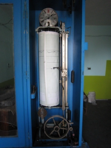
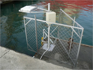
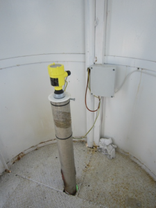
According to the decision of the Council of Ministers in 2012 sea level stations in Varna, Irakly, Burgas and Ahtopol will be operated jointly by Bulgarian Academy of Sciences and CA. In 2012 high accuracy microwave instruments able to provide real time data were installed at Port Varna and port Burgas. In 2019 an agreement between CA, IO-BAS and National institute for geophysics, geodesy and geography-BAS were signed for collaboration in order to modernize and maintains the national network of sea level stations. Total modernization is planned to make these stations able to produce real time data.

Sea level data is important for research of climatic changes and marine geohazards. Shipping, ports, marine operation and coastal construction uses these data.

Creating a new scientific infrastructure that has not been available so far.